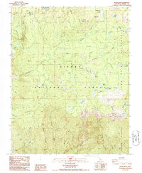
1986 Map of Rough Spur
USGS Topo · Published 1987About this map
Wishon Reservoir and the Wishon Dam anchor the northwest corner of this high-altitude landscape, where the North Fork Kings River carves through the dramatic Granite Gorge. The map illustrates a transition from the managed resources of the Sierra National Forest into the protected expanses of the John Muir Wilderness and Monarch Wilderness. A network of meadows and seasonal water sources, such as Round Corral Meadow, Cow Meadow, and Garlic Meadow Creek, suggests a landscape used for seasonal grazing and wilderness recreation. Human activity is concentrated near the reservoir, evidenced by the Pack Station, Cliff Camp, and a Gaging Station monitoring river flows. Deep within the wilderness areas, the terrain is defined by prominent ridges and peaks like Rodgers Ridge and Hoffman Mtn, with remote alpine water bodies including Spanish Lake and the Geraldine Lakes scattered throughout the high basins.
Find a feature on this map
43 named features on this map. Tap any name to fly to it.
Don’t see what you’re looking for? This feature index may not catch every label — zoom into the map to look around manually.
Map Details
Editions of this 1986 Rough Spur Map
This is the sole edition of this map. No revisions or reprints were ever made.
Other maps of this area

1903 · Tehipite
USGS Topo · 1:125,000

1904 · Kaiser
USGS Topo · 1:125,000

1905 · Tehipite
USGS Topo · 1:125,000

1912 · Mt. Goddard
USGS Topo · 1:125,000

1922 · Trimmer
USGS Topo · 1:96,000

1924 · Dinuba
USGS Topo · 1:125,000

1947 · Mariposa
USGS Topo · 1:250,000

1948 · Fresno
USGS Topo · 1:250,000

1948 · Mariposa
USGS Topo · 1:250,000

1952 · Tehipite Dome
USGS Topo · 1:62,500