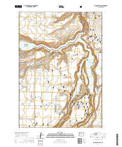
2020 Map of Round Butte Dam
USGS Topo · Published 2020About this map
Round Butte Dam stands as the central engineering landmark of this Jefferson County landscape, where the confluence of three major river systems creates a complex watery geography. The impounded waters of Lake Billy Chinook and Lake Simtustus fill the deep incisions of the Metolius Canyon, Deschutes Canyon, and the Crooked River. This 2020 survey illustrates how modern infrastructure and conservation efforts define the region, with the Crooked River National Grassland spanning large portions of the terrain. Unique landforms such as The Island and The Peninsula are preserved between the high canyon walls, while flat-topped features like Metolius Bench and Canadian Bench provide a stark contrast to the surrounding gorges. Remote access is facilitated by the Lake Billy Chinook State Airport and a network of secondary roads including SW Dynamite Ln and SW Pixie Ln.
Find a feature on this map
47 named features on this map. Tap any name to fly to it.
Don’t see what you’re looking for? This feature index may not catch every label — zoom into the map to look around manually.
Map Details
Editions of this 2020 Round Butte Dam Map
This is the sole edition of this map. No revisions or reprints were ever made.
Other maps of this area

1926 · Bend
USGS Topo · 1:125,000

1928 · Madras
USGS Topo · 1:125,000

1929 · Bend
USGS Topo · 1:125,000

1931 · Madras
USGS Topo · 1:125,000

1955 · Bend
USGS Topo · 1:250,000

1957 · Bend
USGS Topo · 1:250,000

1958 · Bend
USGS Topo · 1:250,000

1962 · Metolius Bench
USGS Topo · 1:24,000

1962 · Opal City
USGS Topo · 1:24,000

1962 · Fly Creek
USGS Topo · 1:24,000