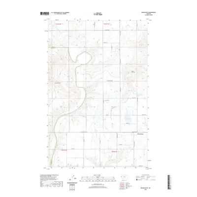
2020 Map of Round Butte
USGS Topo · Published 2020About this map
The Flathead River carves a winding path through this portion of Lake and Sanders counties, defining the western edge of a landscape shaped by both natural topography and extensive irrigation. To the east, the Valley View Hills rise above a network of water management features essential to the region's agricultural character, including the Horte Reservoir, the Pablo A Canal, and the Pablo 7 3A14 Ditch. Near the southern boundary, the prominent landmark of Round Butte overlooks a grid of rural routes such as Moise Valley Rd and Sloan Rd. This 2020 survey illustrates the modern layout of these irrigation corridors and the enduring importance of the river breaks, which remain largely undeveloped compared to the organized agricultural plots surrounding the Pablo 70a Canal.
Find a feature on this map
36 named features on this map. Tap any name to fly to it.
Don’t see what you’re looking for? This feature index may not catch every label — zoom into the map to look around manually.
Map Details
Editions of this 2020 Round Butte Map
This is the sole edition of this map. No revisions or reprints were ever made.
Other maps of this area

1920 · Flathead Lake
USGS Topo · 1:125,000

1956 · Wallace
USGS Topo · 1:250,000

1960 · Wallace
USGS Topo · 1:250,000

1964 · Buffalo Bridge
USGS Topo · 1:24,000

1964 · Melton Ranch
USGS Topo · 1:24,000

1964 · Polson
USGS Topo · 1:24,000

1964 · Lower Crow Reservoir
USGS Topo · 1:24,000

1965 · Sloan
USGS Topo · 1:24,000

1965 · Oliver Point
USGS Topo · 1:24,000
1965 · Irvine Hill
USGS Topo · 1:24,000