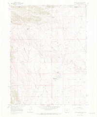
1967 Map of Round Butte
USGS Topo · Published 1971About this map
The Wyoming Colorado state line bisects this 1967 survey, where the arid high plains of Laramie and Larimer Counties meet. This is a landscape defined by livestock and logistics, anchored by several operational encampments including Brannigan Camp and the series of camps at Jack Springs. The terrain is characterized by the prominent volcanic profile of Round Butte and the flanking waters of the Round Butte Reservoirs. An Old Railroad Grade traverses the eastern sections near Spottlewood Creek, suggesting the historical reach of industrial transport into these remote grazing lands. Water is the primary driver of development here, evident in the numerous named sources like Soapstone Springs and the Flowing Well that support the ranching infrastructure across the Flats.
Find a feature on this map
26 named features on this map. Tap any name to fly to it.
Don’t see what you’re looking for? This feature index may not catch every label — zoom into the map to look around manually.
Map Details
Editions of this 1967 Round Butte Map
3 editions found
Other maps of this area

1905 · Sherman
USGS Topo · 1:125,000

1907 · Livermore
USGS Topo · 1:125,000

1908 · Eaton
USGS Topo · 1:125,000

1909 · Livermore
USGS Topo · 1:125,000

1910 · Eaton
USGS Topo · 1:125,000

1911 · Cheyenne
USGS Topo · 1:125,000

1914 · Cheyenne
USGS Topo · 1:125,000

1950 · Cheyenne
USGS Topo · 1:62,500

1954 · Cheyenne
USGS Topo · 1:250,000

1954 · Greeley
USGS Topo · 1:250,000