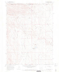
1967 Map of Round Butte
USGS Topo · Published 1971About this map
Spottlewood Creek and Rawhide Creek carve through the high-plains landscape along the Colorado and Wyoming border in this late 1960s survey. The map reveals a specialized cattle-ranching or sheep-herding infrastructure, characterized by numerous named outposts such as Soapstone Camp, Brannigan Camp, and Graves Camp. This settlement pattern, consisting of isolated camps rather than formal townships, reflects the open-range heritage of the high desert plateau north of Fort Collins.
Find a feature on this map
27 named features on this map. Tap any name to fly to it.
Don’t see what you’re looking for? This feature index may not catch every label — zoom into the map to look around manually.
Map Details
Editions of this 1967 Round Butte Map
3 editions found
Other maps of this area

1905 · Sherman
USGS Topo · 1:125,000

1907 · Livermore
USGS Topo · 1:125,000

1908 · Eaton
USGS Topo · 1:125,000

1909 · Livermore
USGS Topo · 1:125,000

1910 · Eaton
USGS Topo · 1:125,000

1911 · Cheyenne
USGS Topo · 1:125,000

1914 · Cheyenne
USGS Topo · 1:125,000

1950 · Cheyenne
USGS Topo · 1:62,500

1954 · Cheyenne
USGS Topo · 1:250,000

1954 · Greeley
USGS Topo · 1:250,000