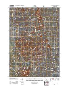
2011 Map of Round Mountain
USGS Topo · Published 2011About this map
Round Mountain and Lookout Mountain anchor this landscape in the Deschutes National Forest region, characterized by a dense network of volcanic peaks and forestry service roads. The geography is dominated by numerous cinder cones and buttes, including Siah Butte, Lolah Butte, and Lumrum Butte, which reflect the area's volcanic heritage. Movement through the terrain is facilitated by Round Mountain Pass, a critical point for travelers navigating the elevation changes of the high desert backcountry.
Find a feature on this map
29 named features on this map. Tap any name to fly to it.
Don’t see what you’re looking for? This feature index may not catch every label — zoom into the map to look around manually.
Map Details
Editions of this 2011 Round Mountain Map
This is the sole edition of this map. No revisions or reprints were ever made.
Other maps of this area

1930 · Maiden Peak
USGS Topo · 1:125,000

1934 · Maiden Peak
USGS Topo · 1:125,000

1955 · Crescent
USGS Topo · 1:250,000

1957 · Crescent
USGS Topo · 1:250,000

1958 · Crescent
USGS Topo · 1:250,000
1963 · Elk Lake
USGS Topo · 1:24,000

1963 · Round Mountain
USGS Topo · 1:24,000
1963 · Wanoga Butte
USGS Topo · 1:24,000

1963 · La Pine
USGS Topo · 1:24,000
1963 · Pistol Butte
USGS Topo · 1:24,000