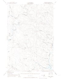
1955 Map of Round Pond
USGS Topo · Published 1957About this map
The St John River and its major tributaries define this mid-century survey of the northern Maine woods, capturing a remote landscape managed for forestry and border security. The confluence of the Big Black River and the St. John is marked by the Immigration Service Camp and a Forest Service Camp, signifying the area's role as a monitored frontier. Navigation along these waterways is punctuated by natural obstacles like Big Black Rapids and Priestly Rapids, which dictated the movement of timber and travelers before the expansion of modern road networks.
Find a feature on this map
38 named features on this map. Tap any name to fly to it.
Don’t see what you’re looking for? This feature index may not catch every label — zoom into the map to look around manually.
Map Details
Editions of this 1955 Round Pond Map
5 editions found

Other maps of this area

1930 · Allagash
USGS Topo · 1:48,000

1932 · Umsaskis Lake
USGS Topo · 1:48,000

1932 · Musquacook Lakes
USGS Topo · 1:48,000

1932 · Allagash Falls
USGS Topo · 1:48,000

1933 · Allagash
USGS Topo · 1:62,500

1935 · Umsaskis Lake
USGS Topo · 1:62,500

1935 · Musquacook Lakes
USGS Topo · 1:62,500

1935 · Allagash Falls
USGS Topo · 1:62,500

1954 · Presque Isle
USGS Topo · 1:250,000

1955 · Rocky Mountain
USGS Topo · 1:62,500