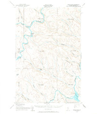
1955 Map of Round Pond
USGS Topo · Published 1967About this map
The St John River and Allagash River converge within this remote northern Maine landscape, illustrating a wilderness shaped by forestry and border enforcement in the mid-1950s. The map reveals specialized outpost settlements such as the Immigration Service Camp and Forest Service Camp located near the riverbanks, alongside a Game Warden Camp situated near the southeastern waters of Round Pond.
Find a feature on this map
38 named features on this map. Tap any name to fly to it.
Don’t see what you’re looking for? This feature index may not catch every label — zoom into the map to look around manually.
Map Details
Editions of this 1955 Round Pond Map
5 editions found

Other maps of this area

1930 · Allagash
USGS Topo · 1:48,000

1932 · Umsaskis Lake
USGS Topo · 1:48,000

1932 · Musquacook Lakes
USGS Topo · 1:48,000

1932 · Allagash Falls
USGS Topo · 1:48,000

1933 · Allagash
USGS Topo · 1:62,500

1935 · Umsaskis Lake
USGS Topo · 1:62,500

1935 · Musquacook Lakes
USGS Topo · 1:62,500

1935 · Allagash Falls
USGS Topo · 1:62,500

1954 · Presque Isle
USGS Topo · 1:250,000

1955 · Rocky Mountain
USGS Topo · 1:62,500