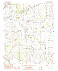
1984 Map of Round Pond
USGS Topo · Published 1985About this map
North Blackfish Bayou and Blackfish Bayou wind through this St. Francis County landscape, defining the drainage patterns and historical settlement sites of the eastern Arkansas Delta. The map reveals a cluster of small rural communities and named crossroads that served as local hubs during the mid-1980s, including Round Pond, Hicks Station, Lucerne, and Whitmore. These locations, often situated along the rail lines or at road junctions, represent the agricultural connectivity of the era. To the south and west, the terrain is dotted with significant water bodies such as Pettijohn Lake and Burnt Cane Lake, while Tenmile Bayou snakes across the central flats. The presence of a Cem and various transmission lines indicates the infrastructure supporting these agricultural settlements, providing a clear view of the transition between the wetlands of Johnson Bend and the developed farmlands of the region.
Find a feature on this map
36 named features on this map. Tap any name to fly to it.
Don’t see what you’re looking for? This feature index may not catch every label — zoom into the map to look around manually.
Map Details
Editions of this 1984 Round Pond Map
2 editions found
Other maps of this area

1931 · Horseshoe Lake
USGS Topo · 1:62,500

1939 · Horseshoe Lake
USGS Topo · 1:62,500

1939 · Park Place
USGS Topo · 1:62,500

1939 · Edmondson
USGS Topo · 1:62,500

1940 · Whitmore
USGS Topo · 1:62,500

1948 · Helena
USGS Topo · 1:250,000

1950 · Helena
USGS Topo · 1:250,000

1953 · Memphis
USGS Topo · 1:250,000

1954 · Horseshoe Lake
USGS Topo · 1:62,500

1954 · Edmondson
USGS Topo · 1:62,500