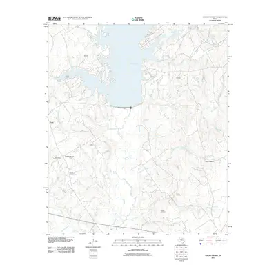
2011 Map of Round Prairie
USGS Topo · Published 2011About this map
Lake Limestone dominates the northern reaches of this landscape, its expansive waters held in place by the Sterling C Robertson Dam. The geography is defined by a dense network of watercourses, including the Navasota River and numerous branches like Dogwood Creek and Birch Creek, which carve through the terrain south of the reservoir. For those researching local family history, the map is remarkably dense with burial grounds, including the Sansom Cemetery, Friendship Cemetery, and the Seale-Round Prairie Cemetery near the settlement of Round Prairie. The distribution of these cemeteries alongside small communities like Seale and Long Hollow suggests a long-established rural social structure centered around these small creek-fed valleys. Many of these sites, such as the Bumpus Cemetery and Grayson Cemetery, are tucked away near the banks of local tributaries, preserving the location of early homesteads and family plots.
Find a feature on this map
28 named features on this map. Tap any name to fly to it.
Don’t see what you’re looking for? This feature index may not catch every label — zoom into the map to look around manually.
Map Details
Editions of this 2011 Round Prairie Map
This is the sole edition of this map. No revisions or reprints were ever made.
Other maps of this area

1925 · Marquez No. 1
USGS Topo · 1:48,000

1927 · Marquez
USGS Topo · 1:62,500

1930 · Marquez
USGS Topo · 1:62,500

1954 · Waco
USGS Topo · 1:250,000

1955 · Waco
USGS Topo · 1:250,000

1956 · Jewett
USGS Topo · 1:62,500

1964 · Margie
USGS Topo · 1:24,000

1965 · Jewett
USGS Topo · 1:24,000
1965 · Marquez
USGS Topo · 1:24,000
1965 · Donie
USGS Topo · 1:24,000