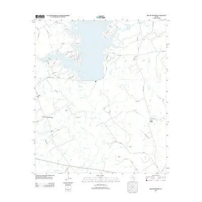
2013 Map of Round Prairie
USGS Topo · Published 2013About this map
Lake Limestone dominates the northern landscape of this Leon County region, where the reservoir's complex shoreline creates numerous inlets fed by Steepleton Br and Kellogg Cr. The surrounding countryside maintains a rural character defined by a network of county roads and family-named cemeteries that speak to the area's deep genealogical roots. Settlements like Round Prairie and Seale are situated west of the Navasota River, which flows southward through the center of the map.
Find a feature on this map
76 named features on this map. Tap any name to fly to it.
Don’t see what you’re looking for? This feature index may not catch every label — zoom into the map to look around manually.
Map Details
Editions of this 2013 Round Prairie Map
This is the sole edition of this map. No revisions or reprints were ever made.
Other maps of this area

1925 · Marquez No. 1
USGS Topo · 1:48,000

1927 · Marquez
USGS Topo · 1:62,500

1930 · Marquez
USGS Topo · 1:62,500

1954 · Waco
USGS Topo · 1:250,000

1955 · Waco
USGS Topo · 1:250,000

1956 · Jewett
USGS Topo · 1:62,500

1964 · Margie
USGS Topo · 1:24,000

1965 · Jewett
USGS Topo · 1:24,000
1965 · Marquez
USGS Topo · 1:24,000
1965 · Donie
USGS Topo · 1:24,000