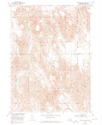
1951 Map of Round Valley
USGS Topo · Published 1978About this map
Lillian Creek carves a path through the dissected hills of Custer County, shaping a landscape defined by its isolated valleys and rural community hubs. The area is anchored by the small settlement of Round Valley, where local history is centered around the Round Valley Cem. This mid-century survey, updated in the 1970s, captures the distribution of rural education before the consolidation of many country districts. The map documents the placement of the Sargent Valley Sch and the Swiss Valley Sch, both located near their namesake drainages of Sargent Valley and Swiss Valley. These schools and cemeteries provide essential coordinates for genealogists tracing family footprints in central Nebraska, reflecting a settlement pattern built around water sources and small-scale ranching and farming operations during the mid-20th century.
Find a feature on this map
12 named features on this map. Tap any name to fly to it.
Don’t see what you’re looking for? This feature index may not catch every label — zoom into the map to look around manually.
Map Details
Editions of this 1951 Round Valley Map
3 editions found

Other maps of this area

1951 · Broken Bow NE
USGS Topo · 1:24,000

1951 · Westerville
USGS Topo · 1:24,000

1951 · Lillian
USGS Topo · 1:24,000

1951 · Broken Bow
USGS Topo · 1:24,000

1951 · Walworth
USGS Topo · 1:24,000

1951 · Round Valley
USGS Topo · 1:24,000

1951 · Milburn
USGS Topo · 1:24,000

1952 · Sargent West
USGS Topo · 1:24,000

1952 · Sargent SW
USGS Topo · 1:24,000

1955 · Broken Bow
USGS Topo · 1:250,000