
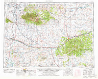
1958 Map of Roundup
USGS Topo · Published 1958About this map
Roundup serves as a focal point in this mid-century survey of Central Montana, where the Musselshell River corridor provides a lifeline for commerce and ranching. The landscape is defined by the dramatic rise of the Big Snowy Mountains and Little Snowy Mountains, areas protected within the Lewis and Clark National Forest. Water management is central to the region's development, evidenced by the Deadman's Basin Reservoir and the Yellow Water storage project. The Great Northern railroad dictates the pattern of settlement, linking small sidings and communities like Oka, Nihill, and Wallum. Evidence of the burgeoning energy sector appears near the river valley with several Oil Wells and Oil tanks, while the Hailstone National Wildlife Refuge marks the conservation efforts of the 1950s. Genealogists may find value in the documented Judith Cemetery and established ranching outposts like the Gibson Ranch Headquarters.
Find a feature on this map
74 named features on this map. Tap any name to fly to it.
Don’t see what you’re looking for? This feature index may not catch every label — zoom into the map to look around manually.
Map Details
Editions of this 1958 Roundup Map
2 editions found
Other maps of this area

1886 · Little Belt Mts.
USGS Topo · 1:250,000

1889 · Big Snowy Mountain
USGS Topo · 1:250,000

1890 · Fort Benton
USGS Topo · 1:250,000

1891 · Livingston
USGS Topo · 1:250,000

1891 · Big Timber
USGS Topo · 1:125,000

1892 · Fort Benton
USGS Topo · 1:250,000

1892 · Stillwater
USGS Topo · 1:125,000

1893 · Livingston
USGS Topo · 1:250,000

1893 · Big Snowy Mountain
USGS Topo · 1:250,000

1893 · Big Timber
USGS Topo · 1:125,000