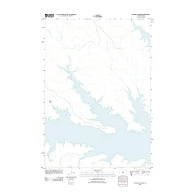
2012 Map of Rousseau Creek
USGS Topo · Published 2012About this map
Lake Oahe dominates this Dewey County landscape, where the Missouri River's impoundment has created a complex shoreline of inlets and submerged valleys. The western reaches of the reservoir are defined by the convergence of several drainages, most notably the system of Rousseau Cr, which splits into the W Br Rousseau Cr and E Br Rousseau Cr. These watercourses, along with Joes Cr and Oak Cr, highlight the drainage patterns that shaped the prairie before the valley was flooded. The map also records distinctive landforms such as Fine Weather Draw and Whiteman Draw, reflecting local naming conventions and the topography of the Missouri Plateau. Further south, the mouth of Camp Cr joins the expanse of the lake, illustrating the significant reach of the reservoir into the surrounding ranching and tribal lands.
Find a feature on this map
9 named features on this map. Tap any name to fly to it.
Don’t see what you’re looking for? This feature index may not catch every label — zoom into the map to look around manually.
Map Details
Editions of this 2012 Rousseau Creek Map
This is the sole edition of this map. No revisions or reprints were ever made.
Other maps of this area

1954 · Pierre
USGS Topo · 1:250,000

1956 · Rousseau Creek SW
USGS Topo · 1:24,000

1956 · Crockett Mountains
USGS Topo · 1:24,000

1958 · Pierre
USGS Topo · 1:250,000

1969 · Rousseau Creek
USGS Topo · 1:24,000

1969 · No Heart Creek SW
USGS Topo · 1:24,000

1973 · Iron Post Buttes
USGS Topo · 1:24,000

1981 · Charlie Creek
USGS Topo · 1:24,000

1981 · Rousseau Creek NW
USGS Topo · 1:24,000
1981 · No Heart Creek
USGS Topo · 1:24,000