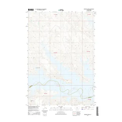
2015 Map of Rousseau Creek
USGS Topo · Published 2015About this map
Lake Oahe dominates this central South Dakota landscape, where the waters of the Missouri River reservoir meet the deeply eroded breaks of the surrounding plains. The map illustrates the boundary between Dewey Co and Stanley Co, tracing the submerged path of the river. The terrain is defined by a network of drainage systems, including Rousseau Cr and its tributaries, the W Br Rousseau Cr and E Br Rousseau Cr, which feed into the northern reaches of the lake. To the south, Camp Cr and Oak Cr carve through the land before reaching the water's edge. The sparse infrastructure consists primarily of Bia-803, providing access to this section of the Cheyenne River Reservation. Named topographic depressions like Fine Weather Draw and Whiteman Draw provide specific landmarks within the high-relief landscape surrounding the reservoir.
Find a feature on this map
17 named features on this map. Tap any name to fly to it.
Don’t see what you’re looking for? This feature index may not catch every label — zoom into the map to look around manually.
Map Details
Editions of this 2015 Rousseau Creek Map
This is the sole edition of this map. No revisions or reprints were ever made.
Other maps of this area

1954 · Pierre
USGS Topo · 1:250,000

1956 · Rousseau Creek SW
USGS Topo · 1:24,000

1956 · Crockett Mountains
USGS Topo · 1:24,000

1958 · Pierre
USGS Topo · 1:250,000

1969 · Rousseau Creek
USGS Topo · 1:24,000

1969 · No Heart Creek SW
USGS Topo · 1:24,000

1973 · Iron Post Buttes
USGS Topo · 1:24,000

1981 · Charlie Creek
USGS Topo · 1:24,000

1981 · Rousseau Creek NW
USGS Topo · 1:24,000
1981 · No Heart Creek
USGS Topo · 1:24,000