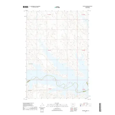
2017 Map of Rousseau Creek
USGS Topo · Published 2017About this map
Lake Oahe dominates the southern and eastern landscape of this Dewey County region, where the Missouri River's dammed waters back into complex, finger-like inlets. The hydrology is defined by northern drainage systems like Rousseau Cr, including its west and east branches, and Joes Cr, which carve through the high prairie before meeting the reservoir. This modern survey illustrates how the inundation of the valley floor transformed the local geography, creating deep draws such as Fine Weather Draw and Whiteman Draw that now terminate at the water's edge. Access to these remote shorelines is maintained by a sparse network of roads, notably Bia Rd 803, which reflects the ongoing importance of Bureau of Indian Affairs infrastructure in managing the land near the Dewey and Stanley County line.
Find a feature on this map
18 named features on this map. Tap any name to fly to it.
Don’t see what you’re looking for? This feature index may not catch every label — zoom into the map to look around manually.
Map Details
Editions of this 2017 Rousseau Creek Map
This is the sole edition of this map. No revisions or reprints were ever made.
Other maps of this area

1954 · Pierre
USGS Topo · 1:250,000

1956 · Rousseau Creek SW
USGS Topo · 1:24,000

1956 · Crockett Mountains
USGS Topo · 1:24,000

1958 · Pierre
USGS Topo · 1:250,000

1969 · Rousseau Creek
USGS Topo · 1:24,000

1969 · No Heart Creek SW
USGS Topo · 1:24,000

1973 · Iron Post Buttes
USGS Topo · 1:24,000

1981 · Charlie Creek
USGS Topo · 1:24,000

1981 · Rousseau Creek NW
USGS Topo · 1:24,000
1981 · No Heart Creek
USGS Topo · 1:24,000