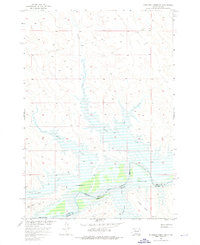
1956 Map of Rousseau Creek SW
USGS Topo · Published 1976About this map
The Cheyenne River Indian Reservation Boundary marks a significant division in this mid-century landscape along the Cheyenne River. At the time of this 1956 field check, the region was characterized by isolated homesteads like Holloway Ranch and Chisholm Ranch, situated near the confluence of Minneconjou Creek and the main river valley. This survey was conducted as part of the Missouri River Basin development program, specifically noting areas intended for submergence by the planned Lake Oahe at an elevation of 1620 feet. This detail provides an essential record of the original riverbanks and creek beds, such as Fishgut Creek and Sage Creek, before the landscape was altered by massive flood control projects. The topography transitions from named plains like Rich Flats and Little Flats to the dissected drainage networks that feed into the Cheyenne from both Dewey and Stanley Counties.
Find a feature on this map
14 named features on this map. Tap any name to fly to it.
Don’t see what you’re looking for? This feature index may not catch every label — zoom into the map to look around manually.
Map Details
Editions of this 1956 Rousseau Creek SW Map
3 editions found
Other maps of this area

1954 · Pierre
USGS Topo · 1:250,000

1956 · Rousseau Creek SW
USGS Topo · 1:24,000

1956 · Herbert Creek SE
USGS Topo · 1:24,000

1956 · Sansarc NE
USGS Topo · 1:24,000

1956 · Crockett Mountains
USGS Topo · 1:24,000

1958 · Pierre
USGS Topo · 1:250,000

1969 · Rousseau Creek
USGS Topo · 1:24,000

1981 · Charlie Creek
USGS Topo · 1:24,000

1981 · Rousseau Creek NW
USGS Topo · 1:24,000

1981 · Herbert Creek NE
USGS Topo · 1:24,000