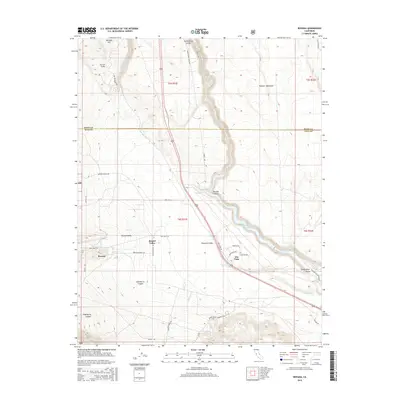
2015 Map of Rovana
USGS Topo · Published 2015About this map
Round Valley and the small settlements of Rovana and Alta Vista anchor this portion of the Eastern Sierra foothills at the Mono and Inyo County line. The landscape is defined by the dramatic transition from the Volcanic Tableland in the east to the deep incisions of the Owens River Gorge. Infrastructure for water and industry is evident throughout, from the Owens Gorge Pipeline to the Pleasant Valley Reservoir. Local history and industry are further reflected in the naming of thoroughfares such as Vanadium Ranch Rd and Round Valley Tungsten Rd, which suggest the area's geological and mining heritage. The rugged eastern terrain is marked by Birchim Canyon and Elderberry Canyon, while the north is dominated by the steep ascent of the Sherwin Grade up toward Sherwin Hill. These varied features illustrate a landscape shaped by both significant volcanic activity and the engineering required to manage mountain water resources.
Find a feature on this map
39 named features on this map. Tap any name to fly to it.
Don’t see what you’re looking for? This feature index may not catch every label — zoom into the map to look around manually.
Map Details
Editions of this 2015 Rovana Map
This is the sole edition of this map. No revisions or reprints were ever made.
Other maps of this area

1912 · Mt. Goddard
USGS Topo · 1:125,000

1913 · Bishop
USGS Topo · 1:125,000

1914 · Mt. Morrison
USGS Topo · 1:125,000

1917 · White Mountain
USGS Topo · 1:125,000

1947 · Mariposa
USGS Topo · 1:250,000

1948 · Mariposa
USGS Topo · 1:250,000

1949 · Mt. Tom
USGS Topo · 1:62,500

1949 · Bishop
USGS Topo · 1:62,500

1951 · Mt. Tom
USGS Topo · 1:62,500

1951 · Bishop
USGS Topo · 1:62,500