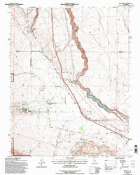
1994 Map of Rovana
USGS Topo · Published 1997About this map
Round Valley is the focal point of this mid-1990s survey, where the dramatic elevation change between the Sherwin Hill slopes and the Volcanic Tableland dictates the area's infrastructure. The community of Rovana sits at the foot of the mountains, defined by its proximity to Pine Creek and the presence of specialized local landmarks like the Ranch Sewage Disposal Pond. To the east, the Owens River Gorge snakes through the terrain, leading toward the Pleasant Valley Reservoir. This landscape reflects a careful management of water and energy resources, evidenced by the prominent Aqueduct, a Powerhouse near Birchim Canyon, and a Surge Tank overlooking the gorge. Industrial history is etched into the hillsides at the Western X Mine within the Tungsten Hills, while the presence of the Round Valley School and the Paradise Camp settlement shows the established residential and recreational pockets of the Owens Valley during this era.
Find a feature on this map
37 named features on this map. Tap any name to fly to it.
Don’t see what you’re looking for? This feature index may not catch every label — zoom into the map to look around manually.
Map Details
Editions of this 1994 Rovana Map
This is the sole edition of this map. No revisions or reprints were ever made.
Other maps of this area

1912 · Mt. Goddard
USGS Topo · 1:125,000

1913 · Bishop
USGS Topo · 1:125,000

1914 · Mt. Morrison
USGS Topo · 1:125,000

1917 · White Mountain
USGS Topo · 1:125,000

1947 · Mariposa
USGS Topo · 1:250,000

1948 · Mariposa
USGS Topo · 1:250,000

1949 · Mt. Tom
USGS Topo · 1:62,500

1949 · Bishop
USGS Topo · 1:62,500

1951 · Mt. Tom
USGS Topo · 1:62,500

1951 · Bishop
USGS Topo · 1:62,500