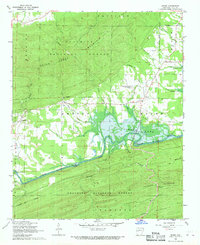
1968 Map of Rover
USGS Topo · Published 1970About this map
Nimrod Lake and the winding Fourche La Fave River dominate this Yell County landscape as it appeared in the late 1960s. The water system, including Dutch Creek and Twomile Creek, dictates the location of small settlements like Rover, Wing, and Briggsville. These communities are tied together by a network of rural roads crossing landmarks such as Whitely Bridge. Significant portions of the terrain are preserved within the Ouachita National Forest, which encompasses high ground like Herring Mountain and Crawford Mountain. Genealogists will find notable burial sites documented here, including Mt Zion Cem and Hunts Chapel Cem, providing clear spatial context for local family histories near the Roadside Park and various mountain ridges.
Find a feature on this map
43 named features on this map. Tap any name to fly to it.
Don’t see what you’re looking for? This feature index may not catch every label — zoom into the map to look around manually.
Map Details
Editions of this 1968 Rover Map
2 editions found
Other maps of this area

1879 · Mountain Home
USGS Topo · 1:62,500

1887 · Magazine Mountain #4
USGS Topo · 1:62,500

1887 · Magazine Mountain
USGS Topo · 1:62,500

1888 · Dardanelle #3
USGS Topo · 1:62,500

1890 · Magazine Mountain
USGS Topo · 1:125,000

1890 · Mount Ida
USGS Topo · 1:125,000

1890 · Hot Springs
USGS Topo · 1:125,000

1890 · Dardanelle
USGS Topo · 1:125,000

1894 · Hot Springs
USGS Topo · 1:125,000

1955 · Little Rock
USGS Topo · 1:250,000