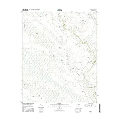
2016 Map of Rowan
USGS Topo · Published 2016About this map
Black River and South River converge in this low-lying region of Bladen, Sampson, and Pender counties, forming a complex network of wetlands and riverine bluffs. The landscape is defined by its numerous elliptical depressions known locally as bays, including Big Bay, Tussock Bay, and Conkill Bay. These geographical features, alongside vast swamp systems like Colly Swamp and Rowan Swamp, dictate the placement of local infrastructure and small communities. Settlement centers on Ivanhoe and Rowan, while the higher ground is dotted with family-named cemeteries such as Bannerman Cem, Sellars Cem, and Anders Cem. Transport through these wetlands relies on key crossings like Beatty Bridge and Dunlap Bridge, while Yonder Airport provides a localized aviation link. The naming of landmarks like Squalling Bluff and Reedy Crossway reflects a long history of navigating this water-dominant North Carolina interior.
Find a feature on this map
72 named features on this map. Tap any name to fly to it.
Don’t see what you’re looking for? This feature index may not catch every label — zoom into the map to look around manually.
Map Details
Editions of this 2016 Rowan Map
This is the sole edition of this map. No revisions or reprints were ever made.
Other maps of this area

1953 · Florence
USGS Topo · 1:250,000

1954 · Florence
USGS Topo · 1:250,000

1954 · White Lake
USGS Topo · 1:62,500

1954 · Acme
USGS Topo · 1:62,500

1954 · Bolton
USGS Topo · 1:62,500

1955 · Atkinson
USGS Topo · 1:62,500
1980 · Point Caswell
USGS Topo · 1:24,000

1982 · Elizabethtown
USGS Topo · 1:100,000
1983 · Point Caswell
USGS Topo · 1:24,000
1984 · Harrells
USGS Topo · 1:24,000