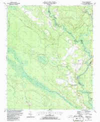
1986 Map of Rowan
USGS Topo · Published 1986About this map
The Black River defines the landscape of this mid-1980s survey, winding along the boundaries of Bladen, Sampson, and Pender counties. The river is a corridor of local history, punctuated by numerous named river access points including Sikes Landing, Henry Landing, and Bakers Landing. These landings suggest a persistent water-based economy and recreational network in an area dominated by expansive lowlands and swampy depressions like Big Bay and Dismal Bay.
Find a feature on this map
42 named features on this map. Tap any name to fly to it.
Don’t see what you’re looking for? This feature index may not catch every label — zoom into the map to look around manually.
Map Details
Editions of this 1986 Rowan Map
This is the sole edition of this map. No revisions or reprints were ever made.
Other maps of this area

1953 · Florence
USGS Topo · 1:250,000

1954 · Florence
USGS Topo · 1:250,000

1954 · White Lake
USGS Topo · 1:62,500

1954 · Acme
USGS Topo · 1:62,500

1954 · Bolton
USGS Topo · 1:62,500

1955 · Atkinson
USGS Topo · 1:62,500
1980 · Point Caswell
USGS Topo · 1:24,000

1982 · Elizabethtown
USGS Topo · 1:100,000
1983 · Point Caswell
USGS Topo · 1:24,000
1984 · Harrells
USGS Topo · 1:24,000