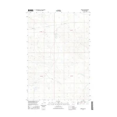
2017 Map of Rowley NW
USGS Topo · Published 2017About this map
Old US Hwy 87 cuts through the northern sections of this Big Horn County landscape, following a route that historically connected the region's agricultural and ranching centers. This 2017 survey details a terrain defined by its complex drainage network, where the waters of Telegraph Cr and Fly Creek navigate the high-plains topography. The map illustrates a strictly rural environment, showing the section lines of the Public Land Survey System that have dictated land ownership and usage since the initial settlement of the Montana territory. In the southeastern corner, the headwaters of the N Fork Two Leggins Cr emerge, further emphasizing the importance of natural water sources in this dry interior climate. This document is a precise record of the land's contours and remaining historical transit corridors in the modern era.
Find a feature on this map
9 named features on this map. Tap any name to fly to it.
Don’t see what you’re looking for? This feature index may not catch every label — zoom into the map to look around manually.
Map Details
Editions of this 2017 Rowley NW Map
This is the sole edition of this map. No revisions or reprints were ever made.
Other maps of this area

1893 · Huntley
USGS Topo · 1:125,000

1894 · Fort Custer
USGS Topo · 1:125,000

1954 · Billings
USGS Topo · 1:250,000

1954 · Hardin
USGS Topo · 1:250,000

1957 · Hardin
USGS Topo · 1:250,000

1957 · Billings
USGS Topo · 1:250,000

1958 · Billings
USGS Topo · 1:250,000

1958 · Hardin
USGS Topo · 1:250,000
1969 · Rowley NW
USGS Topo · 1:24,000
1969 · Rowley
USGS Topo · 1:24,000