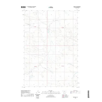
2020 Map of Rowley NW
USGS Topo · Published 2020About this map
The path of Old US Hwy 87 cuts across this high plains landscape of Big Horn County, following a corridor of early motorized travel through southern Montana. The drainage patterns here are defined by several intermittent waterways, most notably Telegraph Cr and the multiple branches of Fly Creek. This territory, divided between the T1S and T2S townships, is a study in Western land surveying and water management. To the south, the N Fork Two Leggins Cr provides further evidence of the complex network of creeks that sustain this portion of the state. The layout of these labels reflects a modern understanding of a landscape that was historically central to cattle ranching and transportation routes between regional hubs.
Find a feature on this map
10 named features on this map. Tap any name to fly to it.
Don’t see what you’re looking for? This feature index may not catch every label — zoom into the map to look around manually.
Map Details
Editions of this 2020 Rowley NW Map
This is the sole edition of this map. No revisions or reprints were ever made.
Other maps of this area

1893 · Huntley
USGS Topo · 1:125,000

1894 · Fort Custer
USGS Topo · 1:125,000

1954 · Billings
USGS Topo · 1:250,000

1954 · Hardin
USGS Topo · 1:250,000

1957 · Hardin
USGS Topo · 1:250,000

1957 · Billings
USGS Topo · 1:250,000

1958 · Billings
USGS Topo · 1:250,000

1958 · Hardin
USGS Topo · 1:250,000
1969 · Rowley NW
USGS Topo · 1:24,000
1969 · Rowley
USGS Topo · 1:24,000