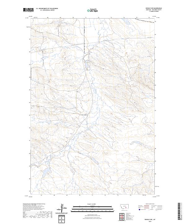
2024 Map of Rowley NW
USGS Topo · Published 2024About this map
The high plains of Big Horn County are defined by the convergence of drainage networks and historical transport corridors. Telegraph Creek meanders through the northwest, while Fly Creek bisects the terrain from north to south, creating a series of subtle draws and ridges characteristic of this Montana landscape. Running across the northern sections of the map, Old Us Hwy 87 serves as the primary artery, tracing a route that predates the modern interstate era and reflects the earlier automotive history of the region. The map detail is largely dictated by the Public Land Survey System, with the intersections of t1s r30e, t1s r31e, t2s r30e, and t2s r31e providing a grid for land ownership and agricultural planning in this open country.
Find a feature on this map
8 named features on this map. Tap any name to fly to it.
Don’t see what you’re looking for? This feature index may not catch every label — zoom into the map to look around manually.
Map Details
Editions of this 2024 Rowley NW Map
This is the sole edition of this map. No revisions or reprints were ever made.
Other maps of this area

1893 · Huntley
USGS Topo · 1:125,000

1894 · Fort Custer
USGS Topo · 1:125,000

1954 · Billings
USGS Topo · 1:250,000

1954 · Hardin
USGS Topo · 1:250,000

1957 · Hardin
USGS Topo · 1:250,000

1957 · Billings
USGS Topo · 1:250,000

1958 · Billings
USGS Topo · 1:250,000

1958 · Hardin
USGS Topo · 1:250,000
1969 · Rowley NW
USGS Topo · 1:24,000
1969 · Rowley
USGS Topo · 1:24,000