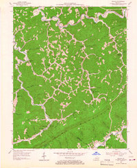
1954 Map of Roxana
USGS Topo · Published 1967About this map
The North Fork Kentucky River and the Cumberland River define this 1954 landscape, separated by the massive ridge of Pine Mountain. Along these waterways and the narrow hollows that feed them, a network of rural schools serves the small communities of Letcher County and Harlan County, including the Mill Branch Sch and Whittaker Sch. The industrial presence of the Louisville and Nashville railroad tracks the river valley near Roxana, where the unusual Hot Spot Premium PO stands as a local landmark.
Find a feature on this map
72 named features on this map. Tap any name to fly to it.
Don’t see what you’re looking for? This feature index may not catch every label — zoom into the map to look around manually.
Map Details
Editions of this 1954 Roxana Map
Other maps of this area

1887 · Jonesville
USGS Topo · 1:125,000

1890 · Whitesburg
USGS Topo · 1:125,000

1891 · Hazard
USGS Topo · 1:125,000

1891 · Jonesville
USGS Topo · 1:125,000

1892 · Whitesburg
USGS Topo · 1:125,000

1894 · Estillville
USGS Topo · 1:125,000

1913 · Oven Fork
USGS Topo · 1:48,000

1915 · Whitesburg
USGS Topo · 1:62,500

1916 · Cornettsville
USGS Topo · 1:62,500

1916 · Nolansburg
USGS Topo · 1:48,000