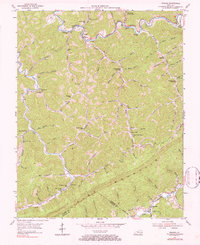
1954 Map of Roxana
USGS Topo · Published 1984About this map
Pine Mountain dominates the southern landscape of this mid-century survey, creating a formidable natural boundary along the Letcher Co Harlan Co line. The steep, narrow hollows and winding ridgelines are dotted with numerous small country schools such as Kingdom Come Sch, Barking Sch, and Davy Sch, reflecting the decentralized community structure of the Appalachian hills. Along the North Fork Kentucky River, the Louisville and Nashville railroad winds through Roxana and past Hot Spot Premium PO, serving the region's coal and timber interests. The intricate network of family-named drainages, including Tolson Branch and Bill Harris Branch, shows how local geography was deeply tied to the families who settled these valleys. Researchers will find a rural landscape transition as small operations like the Oil Well and Gas Well appear alongside traditional mountain settlements like Oscaloosa and Skyline.
Find a feature on this map
78 named features on this map. Tap any name to fly to it.
Don’t see what you’re looking for? This feature index may not catch every label — zoom into the map to look around manually.
Map Details
Editions of this 1954 Roxana Map
Other maps of this area

1887 · Jonesville
USGS Topo · 1:125,000

1890 · Whitesburg
USGS Topo · 1:125,000

1891 · Hazard
USGS Topo · 1:125,000

1891 · Jonesville
USGS Topo · 1:125,000

1892 · Whitesburg
USGS Topo · 1:125,000

1894 · Estillville
USGS Topo · 1:125,000

1913 · Oven Fork
USGS Topo · 1:48,000

1915 · Whitesburg
USGS Topo · 1:62,500

1916 · Cornettsville
USGS Topo · 1:62,500

1916 · Nolansburg
USGS Topo · 1:48,000