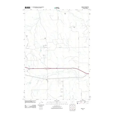
2012 Map of Rozet
USGS Topo · Published 2012About this map
The settlement of Rozet serves as a central point in this Campbell County landscape, where the energy economy and high plains topography meet. Industrial activity is prominent through the Pleasant Valley Oil Field and Rozet Oil Field, which are integrated into a network of local roads such as N Heptner Rd and Rustic Hills Rd. The terrain is marked by distinctive elevations like Indian Tree Hill and Cradle Butte, while the drainage system is defined by the winding paths of Donkey Cr and Cottonwood Cr. Water management in this semi-arid region is evident through several small impoundments, including Jiggs Reservoir and Nelson Reservoir. These features reflect a late 20th and early 21st-century pattern of land use where ranching and resource extraction coexist alongside local thoroughfares like Adon Rd and Sunny Slope Rd.
Find a feature on this map
36 named features on this map. Tap any name to fly to it.
Don’t see what you’re looking for? This feature index may not catch every label — zoom into the map to look around manually.
Map Details
Editions of this 2012 Rozet Map
This is the sole edition of this map. No revisions or reprints were ever made.
Other maps of this area

1954 · Gillette
USGS Topo · 1:250,000

1955 · Gillette
USGS Topo · 1:250,000

1958 · Gillette
USGS Topo · 1:250,000

1962 · Gillette
USGS Topo · 1:250,000

1971 · Coyote Draw
USGS Topo · 1:24,000

1971 · Coon Track Creek
USGS Topo · 1:24,000

1971 · Rozet
USGS Topo · 1:24,000
1971 · Rozet SE
USGS Topo · 1:24,000
1971 · Rozet NE
USGS Topo · 1:24,000
1971 · Rozet NW
USGS Topo · 1:24,000