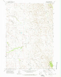
1971 Map of Rozet NW
USGS Topo · Published 1974About this map
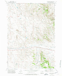
Wagonhammer Butte anchors the northeast corner of this Campbell County landscape, rising above a network of drainages and early energy infrastructure. In the early 1970s, this area was defined by its water sources and the expanding footprint of the petroleum industry, evidenced by the numerous Oil Wells and exploratory Drill Holes scattered across the township lines. The topography is a complex system of draws and creeks, including Cottonwood Creek and its West Fork, which feed into local catchments like the Cliff White Reservoir and School Reservoir. To the south, the terrain transitions toward Little Pine Ridge and the Lone Cedar Spring. This survey captures a specific era of Western land use where traditional cattle ranching resources like Jiggs Res coexisted with the systematic extraction of natural resources.
Find a feature on this map
23 named features on this map. Tap any name to fly to it.
Don’t see what you’re looking for? This feature index may not catch every label — zoom into the map to look around manually.
Map Details
Editions of this 1971 Rozet NW Map
2 editions found
Other maps of this area

1954 · Gillette
USGS Topo · 1:250,000

1955 · Gillette
USGS Topo · 1:250,000

1958 · Gillette
USGS Topo · 1:250,000

1962 · Gillette
USGS Topo · 1:250,000

1971 · Rozet
USGS Topo · 1:24,000
1971 · Rozet SE
USGS Topo · 1:24,000
1971 · Rozet NE
USGS Topo · 1:24,000

1971 · Green Hill
USGS Topo · 1:24,000
1971 · Fortin Draw
USGS Topo · 1:24,000
1972 · Gillette
USGS Topo · 1:100,000