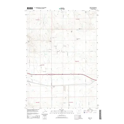
2015 Map of Rozet
USGS Topo · Published 2015About this map
Rozet serves as the central hub of this Campbell County landscape, situated where the high plains meet a complex network of seasonal drainages. The area is defined by the winding course of Donkey Cr and numerous smaller tributaries like Well Cr and W Fork Cottonwood Cr. This modern survey illustrates a landscape of large-scale ranching and infrastructure, where remote reservoirs such as Nelson Reservoir and Jiggs Reservoir provide critical water management for the arid environment. Notable landmarks such as Cradle Butte and Indian Tree Hill rise above the terrain, providing fixed points for navigation. The map also records the presence of the Kissack/Reynolds Airport and a grid of rural routes including Adon Rd and Sinnerville Rd, reflecting the steady development of this Wyoming energy and livestock corridor.
Find a feature on this map
49 named features on this map. Tap any name to fly to it.
Don’t see what you’re looking for? This feature index may not catch every label — zoom into the map to look around manually.
Map Details
Editions of this 2015 Rozet Map
This is the sole edition of this map. No revisions or reprints were ever made.
Other maps of this area

1954 · Gillette
USGS Topo · 1:250,000

1955 · Gillette
USGS Topo · 1:250,000

1958 · Gillette
USGS Topo · 1:250,000

1962 · Gillette
USGS Topo · 1:250,000

1971 · Coyote Draw
USGS Topo · 1:24,000

1971 · Coon Track Creek
USGS Topo · 1:24,000

1971 · Rozet
USGS Topo · 1:24,000
1971 · Rozet SE
USGS Topo · 1:24,000
1971 · Rozet NE
USGS Topo · 1:24,000
1971 · Rozet NW
USGS Topo · 1:24,000