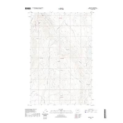
2020 Map of Ruby Hill
USGS Topo · Published 2020About this map
Ruby sits in the northern reaches of this Okanogan County landscape, where the dramatic relief of the Okanogan Highlands is defined by several prominent peaks and ridgelines. The terrain is marked by notable elevations such as Ruby Hill, Arlington Ridge, and Wright Mtn, which overlook a complex network of drainages including Woolloomooloo Cr and Salmon Cr. The distribution of water features, from the high Buzzard Lake to the smaller Reed Pond, suggests a high-elevation plateau environment utilized for ranching or forestry, as evidenced by the naming of various roads like Happy Hill Rd and Windy Hill Rd. To the southeast, the geography transitions into Spring Coulee, near which the Clover Cem stands as a local genealogical landmark. This modern survey provides a clear view of the road systems like Ruby Grade that navigate this often-steep Washington interior.
Find a feature on this map
33 named features on this map. Tap any name to fly to it.
Don’t see what you’re looking for? This feature index may not catch every label — zoom into the map to look around manually.
Map Details
Editions of this 2020 Ruby Hill Map
This is the sole edition of this map. No revisions or reprints were ever made.
Other maps of this area

1905 · Okanogan
USGS Topo · 1:125,000

1906 · Chopaka
USGS Topo · 1:125,000

1954 · Okanogan
USGS Topo · 1:250,000

1956 · Loup Loup
USGS Topo · 1:62,500

1956 · Tiffany Mountain
USGS Topo · 1:62,500

1957 · Okanogan
USGS Topo · 1:62,500

1957 · Conconully
USGS Topo · 1:62,500

1958 · Okanogan
USGS Topo · 1:250,000

1980 · Okanogan
USGS Topo · 1:24,000
1980 · Omak
USGS Topo · 1:24,000