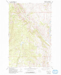
1980 Map of Ruby Hill
USGS Topo · Published 1993About this map
Mining operations define the high ridges and steep drainages of this Okanogan County landscape, where the settlement of Ruby sits nestled below the peaks. Early industrial efforts are preserved through numerous labels for local claims, including the First Thought Mine, Last Chance Mine, and Arlington Mine situated along Arlington Ridge. These sites, along with the Fourth of July Mine, point to a history of extraction that shaped the local economy and movement through the terrain.
Find a feature on this map
30 named features on this map. Tap any name to fly to it.
Don’t see what you’re looking for? This feature index may not catch every label — zoom into the map to look around manually.
Map Details
Editions of this 1980 Ruby Hill Map
This is the sole edition of this map. No revisions or reprints were ever made.
Other maps of this area

1905 · Okanogan
USGS Topo · 1:125,000

1906 · Chopaka
USGS Topo · 1:125,000

1954 · Okanogan
USGS Topo · 1:250,000

1956 · Loup Loup
USGS Topo · 1:62,500

1956 · Tiffany Mountain
USGS Topo · 1:62,500

1957 · Okanogan
USGS Topo · 1:62,500

1957 · Conconully
USGS Topo · 1:62,500

1958 · Okanogan
USGS Topo · 1:250,000

1980 · Okanogan
USGS Topo · 1:24,000
1980 · Omak
USGS Topo · 1:24,000