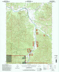
1996 Map of Ruch
USGS Topo · Published 1998About this map
The Applegate River defines the canyon landscape of this Jackson County region, where the small community of Ruch serves as a central hub near the confluence of the Little Applegate River. Much of the terrain is dominated by the steep ridges of the Rogue River National Forest, including prominent heights like Negro Ben Mountain, Squires Peak, and Woodrat Mountain. The valley floor shows a transition from agricultural use and water management, evidenced by several stretches of Ditch and a Diversion Dam, to recreational spaces like Cantrall-Buckley Park. Historical infrastructure is preserved in the location of the McKee Bridge at the southern end of the valley. Local family names are etched into the geography through features such as Offenbacher Point and Offenbacher Gulch, while several Prospect sites on the eastern slopes point to the area's history of mineral exploration.
Find a feature on this map
54 named features on this map. Tap any name to fly to it.
Don’t see what you’re looking for? This feature index may not catch every label — zoom into the map to look around manually.
Map Details
Editions of this 1996 Ruch Map
This is the sole edition of this map. No revisions or reprints were ever made.
Other maps of this area

1891 · Ashland
USGS Topo · 1:250,000

1893 · Ashland
USGS Topo · 1:250,000

1897 · Ashland
USGS Topo · 1:250,000

1908 · Grants Pass
USGS Topo · 1:125,000

1938 · Medford
USGS Topo · 1:125,000

1954 · Medford
USGS Topo · 1:62,500

1954 · Gold Hill
USGS Topo · 1:62,500

1954 · Talent
USGS Topo · 1:62,500

1954 · Ruch
USGS Topo · 1:62,500

1955 · Medford
USGS Topo · 1:250,000