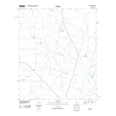
2010 Map of Rucker
USGS Topo · Published 2010About this map
The settlement of Rucker serves as the focal point for this section of Comanche County, where the landscape is defined by the winding paths of the Leon River and the Sabana River. By the early 21st century, the terrain was extensively managed through a complex network of small dams and private reservoirs. These include family-named water bodies such as Eisenrich and Waldron Lake, Arvil Setzler Lake, and Lake Hanson-Taylor, indicating a localized history of ranching and land ownership. The presence of numerous named impoundments like Nabors Lake and Glover Lake highlights the importance of water management in this agricultural region. The map also traces the distinct Weed Valley and several seasonal tributaries, including Hog Creek and Ellison Spring Branch, which feed into the primary river systems. This detailed view captures the specific rural infrastructure of Texas ranch land just before the turn of the decade.
Find a feature on this map
65 named features on this map. Tap any name to fly to it.
Don’t see what you’re looking for? This feature index may not catch every label — zoom into the map to look around manually.
Map Details
Editions of this 2010 Rucker Map
This is the sole edition of this map. No revisions or reprints were ever made.
Other maps of this area

1890 · Stephenville
USGS Topo · 1:125,000

1894 · Eastland
USGS Topo · 1:125,000

1920 · Stephenville
USGS Topo · 1:125,000

1954 · Abilene
USGS Topo · 1:250,000

1958 · Abilene
USGS Topo · 1:250,000

1965 · Huckabay SW
USGS Topo · 1:24,000

1965 · Lingleville
USGS Topo · 1:24,000
1965 · Comyn
USGS Topo · 1:24,000

1966 · Kokomo
USGS Topo · 1:24,000
1966 · Desdemona
USGS Topo · 1:24,000