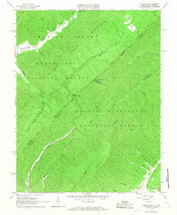
1966 Map of Rucker Gap
USGS Topo · Published 1968About this map
Monongahela National Forest and George Washington National Forest converge at this point along the border of Virginia and West Virginia. The landscape is defined by the high ridges of Middle Mtn, Anthony Creek Mountain, and Oliver Mountain, where numerous drafts and runs carve deep into the terrain. In the northwestern corner, Anthony Creek flows past Columbia Sulphur Springs, an area showing concentrated settlement and local landmarks like Watts Chapel and its adjacent Watts Chapel Cem. The map reveals a network of old transport routes, including the Neola Road and various Jeep Trails, which connected remote mountain homesteads and springs to the larger valleys. This mid-1960s survey captures the intersection of three counties—Greenbrier, Bath, and Alleghany—at Rucker Gap, a critical pass between the watersheds of Meadow Creek and Hughes Draft.
Find a feature on this map
38 named features on this map. Tap any name to fly to it.
Don’t see what you’re looking for? This feature index may not catch every label — zoom into the map to look around manually.
Map Details
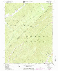
Editions of this 1966 Rucker Gap Map
2 editions found
Other maps of this area

1887 · Lewisburg
USGS Topo · 1:125,000

1891 · Lewisburg
USGS Topo · 1:125,000

1891 · Huntersville
USGS Topo · 1:125,000

1894 · Huntersville
USGS Topo · 1:125,000

1894 · Natural Bridge
USGS Topo · 1:125,000

1901 · Monterey
USGS Topo · 1:125,000

1921 · Callaghan
USGS Topo · 1:48,000

1923 · Marlinton
USGS Topo · 1:48,000

1923 · Warm Springs
USGS Topo · 1:48,000

1923 · Callaghan
USGS Topo · 1:62,500