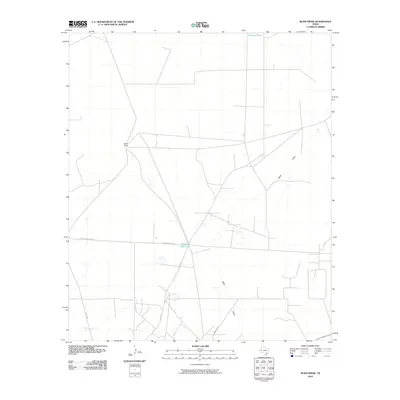
2010 Map of Rudd Draw
USGS Topo · Published 2010About this map
Slash Ranch serves as a primary landmark in this corner of Loving County, illustrating the enduring cattle-ranching legacy in the Texas Permian Basin. This landscape is defined by its drainage systems and water management, with the ephemeral Rudd Draw cutting across the terrain toward various catchment points. Features like Gillespie Tank and Beacon Light Lake reflect the critical infrastructure required for livestock and industry in an arid environment. The map details a network of rural transit, including Reeves County 440 and Co Rd 300, which weave through the wide-open ranch lands. This 2010 edition from the U.S. Geological Survey documents the area before the most recent decade of intensive energy development, preserving a view of the traditional land use and remote county road networks of West Texas.
Find a feature on this map
8 named features on this map. Tap any name to fly to it.
Don’t see what you’re looking for? This feature index may not catch every label — zoom into the map to look around manually.
Map Details
Editions of this 2010 Rudd Draw Map
This is the sole edition of this map. No revisions or reprints were ever made.
Other maps of this area

1954 · Pecos
USGS Topo · 1:250,000

1957 · Pecos
USGS Topo · 1:250,000

1961 · Mentone
USGS Topo · 1:24,000

1961 · Anderson Ranch
USGS Topo · 1:24,000

1961 · Lindley Ranch
USGS Topo · 1:24,000

1967 · Soda Lake NW
USGS Topo · 1:24,000

1969 · Kyle Ranch
USGS Topo · 1:24,000

1969 · Cheyenne Draw SW
USGS Topo · 1:24,000

1969 · Rudd Draw NE
USGS Topo · 1:24,000
1969 · Rudd Draw
USGS Topo · 1:24,000