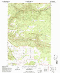
1994 Map of Rudo
USGS Topo · Published 1997About this map
Fraser sits at the southern edge of this Idaho terrain, marking a transition between the more developed forest system lands and the open landscape of Clearwater County. The topography is dominated by a series of drainages, most notably the winding paths of Rudo Creek and Prairie Creek. Revised in the mid-1990s by the Forest Service, this map provides a clear view of the primary and secondary road networks that provide access to this timber-heavy region. The concentration of structures and cleared land near the settlement of Fraser suggests a pocket of rural activity and residency amidst the surrounding Clearwater National Forest, where the landscape is largely shaped by its hydrological network and elevation changes.
Find a feature on this map
3 named features on this map. Tap any name to fly to it.
Don’t see what you’re looking for? This feature index may not catch every label — zoom into the map to look around manually.
Map Details
Editions of this 1994 Rudo Map
This is the sole edition of this map. No revisions or reprints were ever made.
Other maps of this area

1923 · Washington Creek
USGS Topo · 1:125,000

1924 · Kamiah
USGS Topo · 1:125,000

1924 · Weippe
USGS Topo · 1:125,000

1938 · Headquarters
USGS Topo · 1:48,000

1944 · Headquarters
USGS Topo · 1:62,500

1955 · Pullman
USGS Topo · 1:250,000

1956 · Hamilton
USGS Topo · 1:250,000

1958 · Pullman
USGS Topo · 1:250,000

1959 · Hamilton
USGS Topo · 1:250,000

1960 · Hamilton
USGS Topo · 1:250,000