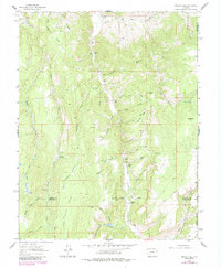
1962 Map of Rudolph Hill
USGS Topo · Published 1984About this map
Cebolla Creek bisects this high-elevation landscape, carving a deep valley through the center of the quadrangle while serving as a primary corridor for early settlement. The map documents the scattered rural infrastructure of the early 1960s, notably the Sammons Ranch and Jardine Ranch to the north, and the Youmans Ranch further south. Genealogists may find interest in the Powderhorn Cem located near the confluence of West Fork Powderhorn Creek and Dry Powderhorn Creek.
Find a feature on this map
49 named features on this map. Tap any name to fly to it.
Don’t see what you’re looking for? This feature index may not catch every label — zoom into the map to look around manually.
Map Details
Editions of this 1962 Rudolph Hill Map
3 editions found
Other maps of this area

1908 · Uncompahgre
USGS Topo · 1:125,000

1911 · Uncompahgre
USGS Topo · 1:125,000

1954 · Gateview
USGS Topo · 1:24,000

1956 · Montrose
USGS Topo · 1:250,000

1959 · Montrose
USGS Topo · 1:250,000

1960 · Montrose
USGS Topo · 1:250,000

1962 · Rudolph Hill
USGS Topo · 1:24,000

1962 · Powderhorn
USGS Topo · 1:24,000
1962 · Spring Hill Creek
USGS Topo · 1:24,000
1963 · Cannibal Plateau
USGS Topo · 1:24,000