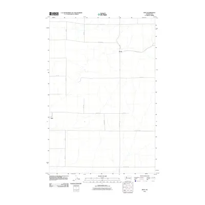
2011 Map of Ruff
USGS Topo · Published 2011About this map
The settlement of Ruff anchors this 2011 survey of a specialized agricultural landscape in Grant County. Defined by a strictly organized grid of rural roads, the area showcases a pattern of large-scale land management characteristic of the region. The map tracks many family-named routes, including W Griffith Rd, W Rehn Rd, and Schoessler Rd W, which serve as the primary conduits between scattered homesteads and the small community at Moody. Most of the terrain is marked by the subtle drainages and intermittent watercourses that navigate through the plateau, emphasizing the importance of these established road networks like Tokio Rd W for local connectivity in a high-desert environment.
Find a feature on this map
19 named features on this map. Tap any name to fly to it.
Don’t see what you’re looking for? This feature index may not catch every label — zoom into the map to look around manually.
Map Details
Editions of this 2011 Ruff Map
This is the sole edition of this map. No revisions or reprints were ever made.
Other maps of this area

1923 · Wheeler
USGS Topo · 1:62,500

1925 · Wheeler
USGS Topo · 1:62,500

1925 · Schrag
USGS Topo · 1:62,500

1953 · Ritzville
USGS Topo · 1:250,000
1956 · Bassett Junction
USGS Topo · 1:24,000

1956 · Wheeler NE
USGS Topo · 1:24,000

1956 · Wilson Creek SE
USGS Topo · 1:24,000

1956 · Wilson Creek
USGS Topo · 1:62,500
1956 · Wheeler
USGS Topo · 1:62,500

1959 · Ritzville
USGS Topo · 1:250,000