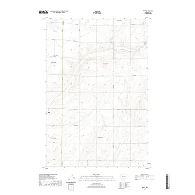
2020 Map of Ruff
USGS Topo · Published 2020About this map
The tiny agricultural settlement of Ruff stands as a focal point in this eastern Washington landscape, situated near the western edge of the quadrangle. The surrounding terrain is defined by the unique geological formations of the Channeled Scablands, evidenced by the deep incisions of Sand Coulee, Rocky Branch Coulee, and Rocky Coulee. These features represent the dramatic erosional history of the region, cutting through the high plateau. The map also captures the administrative boundary of Grant Co Adams Co, which divides the township lines of t20n r31e and t19n r30e. A network of rural roads, including W Schoessler Rd and W Rosenoff Rd, follows the rigid Public Land Survey System grid, illustrating how agricultural development was imposed upon this complex, coulee-scarred topography near the small locality of Moody.
Find a feature on this map
34 named features on this map. Tap any name to fly to it.
Don’t see what you’re looking for? This feature index may not catch every label — zoom into the map to look around manually.
Map Details
Editions of this 2020 Ruff Map
This is the sole edition of this map. No revisions or reprints were ever made.
Other maps of this area

1923 · Wheeler
USGS Topo · 1:62,500

1925 · Wheeler
USGS Topo · 1:62,500

1925 · Schrag
USGS Topo · 1:62,500

1953 · Ritzville
USGS Topo · 1:250,000
1956 · Bassett Junction
USGS Topo · 1:24,000

1956 · Wheeler NE
USGS Topo · 1:24,000

1956 · Wilson Creek SE
USGS Topo · 1:24,000

1956 · Wilson Creek
USGS Topo · 1:62,500
1956 · Wheeler
USGS Topo · 1:62,500

1959 · Ritzville
USGS Topo · 1:250,000