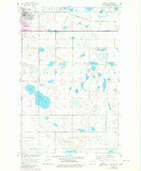
1955 Map of Rugby
USGS Topo · Published 1980About this map
Rugby serves as the focal point of this Pierce County survey, famously designated as the Geographical Center of North America Monument. The town's grid is defined by its proximity to the Great Northern railway, which cuts horizontally across the northern landscape. Local life in the mid-1950s is evidenced by several educational landmarks including Lincoln Sch No 1, School No 1, and the central High Sch. Beyond the residential streets, the terrain is dotted with small prairie potholes and larger bodies of water such as Gunderson Lake. The map details the transition from the structured town life of Rugby to the rural expanses of Turgerson and Meyer townships. Religious and community markers like Little Flower Cem and the mid-century Drive-in Theater reflect the social fabric of this North Dakota prairie hub during its post-war development.
Find a feature on this map
16 named features on this map. Tap any name to fly to it.
Don’t see what you’re looking for? This feature index may not catch every label — zoom into the map to look around manually.
Map Details
Editions of this 1955 Rugby Map
2 editions found
Other maps of this area

1953 · Devils Lake
USGS Topo · 1:250,000

1954 · Tunbridge
USGS Topo · 1:24,000

1954 · Rugby NW
USGS Topo · 1:24,000

1954 · Leverich
USGS Topo · 1:24,000

1954 · Minot
USGS Topo · 1:250,000

1955 · Rugby
USGS Topo · 1:24,000

1956 · Devils Lake
USGS Topo · 1:250,000

1958 · Minot
USGS Topo · 1:250,000

1958 · Fillmore
USGS Topo · 1:24,000

1958 · Balta
USGS Topo · 1:24,000