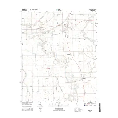
2015 Map of Ruleville
USGS Topo · Published 2015About this map
The Big Sunflower River winds southward through this portion of the Mississippi Delta, anchoring a landscape defined by its waterways and agricultural heritage. The community of Ruleville serves as a central hub in the north, while smaller settlements like Doddsville, Linn, and Dockery are connected by a network of rural roads that follow the section lines of the Public Land Survey System. The region's history is preserved in its numerous family and community burial grounds, including Lehrton Cem, Hillhouse Cem, and Mount Zion Cem. Civil engineering landmarks such as the Old Lehrton Bridge and Hannahs Bridge crossing the Quiver River illustrate the historic necessity of reliable river crossings in this bayou-rich terrain. Smaller water bodies like Burrell Bayou, Daugherty Bayou, and Jones Bayou create a complex hydrological pattern across the flat plains of Sunflower County.
Find a feature on this map
115 named features on this map. Tap any name to fly to it.
Don’t see what you’re looking for? This feature index may not catch every label — zoom into the map to look around manually.
Map Details
Editions of this 2015 Ruleville Map
This is the sole edition of this map. No revisions or reprints were ever made.
Other maps of this area

1931 · Schlater
USGS Topo · 1:48,000

1931 · Sumner
USGS Topo · 1:48,000

1931 · Drew
USGS Topo · 1:48,000

1934 · Cleveland
USGS Topo · 1:62,500

1934 · Schlater
USGS Topo · 1:62,500

1935 · Sumner
USGS Topo · 1:62,500

1935 · Mound Bayou
USGS Topo · 1:62,500

1939 · Schlater
USGS Topo · 1:62,500

1939 · Sumner
USGS Topo · 1:62,500

1940 · Cleveland
USGS Topo · 1:62,500