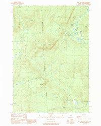
1989 Map of Rump Mountain
USGS Topo · Published 1989About this map
Rump Mountain and the high ridges of the western Maine borderlands define this mountainous landscape in the late 1980s. Straddling the line between Coos County and Oxford County, the area is characterized by an intricate network of waterways including the West Br Magalloway River and the Little Magalloway River. The terrain is marked by significant elevations like Ledge Ridge and Mt Kent, with drainage systems feeding into remote water bodies such as Parmachenee Lake and Rump Pond.
Find a feature on this map
29 named features on this map. Tap any name to fly to it.
Don’t see what you’re looking for? This feature index may not catch every label — zoom into the map to look around manually.
Map Details
Editions of this 1989 Rump Mountain Map
This is the sole edition of this map. No revisions or reprints were ever made.
Other maps of this area

1927 · Moose Bog
USGS Topo · 1:48,000

1927 · Second Lake
USGS Topo · 1:62,500

1931 · Cupsuptic
USGS Topo · 1:48,000

1931 · Moose Bog
USGS Topo · 1:62,500

1932 · Second Lake
USGS Topo · 1:62,500

1932 · Arnold Pond
USGS Topo · 1:48,000

1934 · Cupsuptic
USGS Topo · 1:62,500

1935 · Cupsuptic
USGS Topo · 1:62,500

1935 · Arnold Pond
USGS Topo · 1:62,500

1949 · Jackman
USGS Topo · 1:250,000