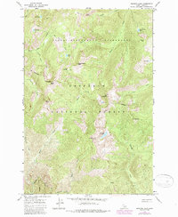
1966 Map of Running Lake
USGS Topo · Published 1987About this map
Running Lake sits at the heart of this high-elevation landscape within the Nezperce National Forest, where steep drainage systems and isolated alpine basins define the terrain. The map documents a primitive transportation network consisting of several Pack Trails, which provided the only access through the Selway-Bitterroot Wilderness before modern revisions. High points like Elk Mountain and Bilk Mountain overlook a series of glacial lakes, including Bilk Lake and Square Rock Lake, which feed the headwaters of major drainages such as Running Creek and Grave Creek.
Find a feature on this map
35 named features on this map. Tap any name to fly to it.
Don’t see what you’re looking for? This feature index may not catch every label — zoom into the map to look around manually.
Map Details
Editions of this 1966 Running Lake Map
3 editions found
Other maps of this area

1911 · Lolo
USGS Topo · 1:250,000

1913 · Lolo
USGS Topo · 1:250,000

1956 · Elk City
USGS Topo · 1:250,000

1956 · Hamilton
USGS Topo · 1:250,000

1959 · Hamilton
USGS Topo · 1:250,000

1960 · Elk City
USGS Topo · 1:250,000

1960 · Hamilton
USGS Topo · 1:250,000

1964 · Hamilton
USGS Topo · 1:250,000

1966 · Moose Ridge
USGS Topo · 1:24,000

1966 · Green Mtn.
USGS Topo · 1:24,000