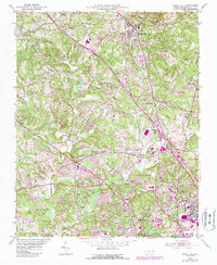
1951 Map of Rural Hall
USGS Topo · Published 1987About this map
The Moravian settlement of Bethania and the railway junction at Rural Hall anchor this 1951 survey of Forsyth County, North Carolina. The landscape is defined by the headwaters of Muddy Creek and its many tributaries, including Mill Creek and Grassy Creek. Significant mid-century institutional sites are prominent, such as the County Sanatorium, County Home, and County Fairgrounds, alongside the educational hub of Old Town Sch.
Find a feature on this map
50 named features on this map. Tap any name to fly to it.
Don’t see what you’re looking for? This feature index may not catch every label — zoom into the map to look around manually.
Map Details
Editions of this 1951 Rural Hall Map
4 editions found
Other maps of this area

1950 · Winston-Salem West
USGS Topo · 1:24,000

1950 · Winston-Salem East
USGS Topo · 1:24,000

1951 · Winston-Salem West
USGS Topo · 1:24,000

1951 · Winston-Salem East
USGS Topo · 1:24,000

1951 · Rural Hall
USGS Topo · 1:24,000

1951 · Walkertown
USGS Topo · 1:24,000

1953 · Winston-Salem
USGS Topo · 1:250,000

1955 · Winston-Salem
USGS Topo · 1:250,000

1962 · Winston-Salem
USGS Topo · 1:250,000

1964 · Pinnacle
USGS Topo · 1:24,000