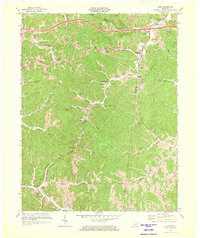
1971 Map of Rush
USGS Topo · Published 1973About this map
The boundary between Boyd Co and Carter Co serves as the backdrop for a landscape defined by its deep coal-mining history and the winding paths of the Ohio and Chesapeake railroad. Small communities like Coalton, Kilgore, and Rush are clustered along these transit corridors, while isolated hilltop mines and extensive strip mines reflect the heavy industrial footprint of the early 1970s. The map documents numerous family-named landmarks and local institutions, such as Ross Chapel, Star Sch, and the Old School Ch near Denton.
Find a feature on this map
46 named features on this map. Tap any name to fly to it.
Don’t see what you’re looking for? This feature index may not catch every label — zoom into the map to look around manually.
Map Details
Editions of this 1971 Rush Map
2 editions found
Other maps of this area

1901 · Ceredo
USGS Topo · 1:62,500

1903 · Kenova
USGS Topo · 1:125,000

1904 · Kenova
USGS Topo · 1:125,000

1911 · Louisa
USGS Topo · 1:48,000

1913 · Ceredo
USGS Topo · 1:62,500

1913 · Louisa
USGS Topo · 1:62,500

1939 · Louisa
USGS Topo · 1:62,500

1953 · Grayson
USGS Topo · 1:24,000

1953 · Oldtown
USGS Topo · 1:24,000

1953 · Rush
USGS Topo · 1:24,000