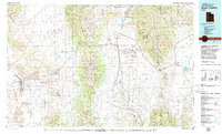
1979 Map of Rush Valley
USGS Topo · Published 1985About this map
The vast military corridors of the Tooele Army Depot and the eastern fringes of the Dugway Proving Ground dominate this 1970s landscape, reflecting the strategic importance of the Utah desert during the Cold War. Between the peaks of the Onaqui Mountains and the Oquirrh Mountains, the basin is dotted with historic mining and railroad history. Small settlements like Ophir and Mercur sit in the canyons of the Oquirrhs, while the Union Pacific line serves valley stations such as St John Station.
Find a feature on this map
94 named features on this map. Tap any name to fly to it.
Don’t see what you’re looking for? This feature index may not catch every label — zoom into the map to look around manually.
Map Details
Editions of this 1979 Rush Valley Map
2 editions found

Other maps of this area

1885 · Salt Lake
USGS Topo · 1:250,000

1885 · Manti
USGS Topo · 1:250,000

1885 · Sevier Desert
USGS Topo · 1:250,000

1885 · Tooele Valley
USGS Topo · 1:250,000

1895 · Manti
USGS Topo · 1:250,000

1908 · Fish Springs
USGS Topo · 1:250,000

1910 · Fish Springs
USGS Topo · 1:250,000

1915 · Fairfield
USGS Topo · 1:62,500

1917 · Fairfield
USGS Topo · 1:62,500

1918 · Stockton
USGS Topo · 1:62,500