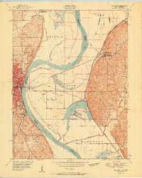
1951 Map of Rushville
USGS Topo · Published 1951About this map
Atchison anchors this 1951 study of the Missouri River's complex bends and lowlands where Kansas and Missouri meet. This post-war era landscape is defined by the sharp curves of the Missouri River, including McQueen Bend and Rushville Bend, which carved out fertile but flood-prone bottoms. The presence of specialized infrastructure like the U S Dept of Agriculture Natural Cooler Storage and the Lewis and Clark State Fish Hatchery indicates the area's agricultural and conservation significance during the mid-century. Educational and social institutions are well-represented, from St Benedicts College and Mt Scholastic Academy in the city to the State Orphan Home nearby. Outside the urban center, a network of rural schools like Schearer Sch and Pleasant Valley School served the farming communities clustered around Sugar Lake and Bean Lake.
Find a feature on this map
52 named features on this map. Tap any name to fly to it.
Don’t see what you’re looking for? This feature index may not catch every label — zoom into the map to look around manually.
Map Details
Editions of this 1951 Rushville Map
2 editions found
Other maps of this area

1885 · Atchison
USGS Topo · 1:125,000

1886 · Oskaloosa
USGS Topo · 1:125,000

1888 · Oskaloosa
USGS Topo · 1:125,000

1888 · Atchison
USGS Topo · 1:125,000

1890 · Kansas City
USGS Topo · 1:125,000

1893 · Atchison
USGS Topo · 1:125,000

1894 · Kansas City
USGS Topo · 1:125,000

1894 · Oskaloosa
USGS Topo · 1:125,000

1910 · Leavenworth
USGS Topo · 1:62,500

1926 · Atchison
USGS Topo · 1:62,500