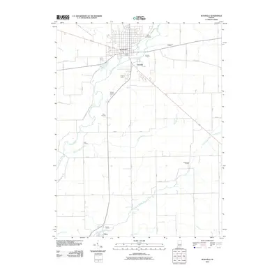
2010 Map of Rushville
USGS Topo · Published 2010About this map
The Flatrock River winds through the heart of Rush County, anchoring a landscape defined by its grid of rural roads and established burial grounds. In the city of Rushville, residential streets give way to historical landmarks like Laughlin Cemetery and East Hill Cemetery, while the small community of Circleville sits just to the southeast. The area's agrarian character is punctuated by several smaller family or community plots, including Kelly Cemetery and Duke Cemetery, which offer valuable locations for genealogical research. Further south, the settlement of Milroy marks the confluence of the Little Flatrock River and Lick Creek. These waterways, along with Harrigan Branch, carve paths through the fields, illustrating the drainage patterns that have dictated the region's agricultural development into the early 21st century.
Find a feature on this map
51 named features on this map. Tap any name to fly to it.
Don’t see what you’re looking for? This feature index may not catch every label — zoom into the map to look around manually.
Map Details
Editions of this 2010 Rushville Map
This is the sole edition of this map. No revisions or reprints were ever made.
Other maps of this area

1942 · Columbus
USGS Topo · 1:125,000

1953 · Cincinnati
USGS Topo · 1:250,000

1957 · Cincinnati
USGS Topo · 1:250,000

1958 · Clarksburg
USGS Topo · 1:24,000

1959 · Milroy
USGS Topo · 1:24,000

1959 · Rushville
USGS Topo · 1:24,000

1959 · New Salem
USGS Topo · 1:24,000
1959 · Adams
USGS Topo · 1:24,000

1959 · Mays
USGS Topo · 1:24,000

1959 · Falmouth
USGS Topo · 1:24,000