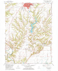
1981 Map of Rushville South
USGS Topo · Published 1981About this map
The county seat of Rushville anchors the northern edge of this Illinois landscape, situated at a transition between the organized street grid of the town and the deeply carved valleys of the Crane Creek watershed. This 1981 survey documents a community shaped by its public institutions and recreation, featuring the Schuy-Rush Park surrounding Schuy-Rush Lake and the Schuy-Rush Airport to the west. For genealogists, the map is remarkably dense with family-named burial grounds including Haardscrabble Cem, Black Cem, and Hosmer Cem. The southern reach of the quadrangle descends toward the Illinois River, where the Bluff Ditch and local Sandpit operations indicate the changing geology of the river bottoms near Cooperstown. From the Courthouse downtown to the Scripps Park Golf Course, the sheet provides a detailed look at Schuyler County life in the early 1980s.
Find a feature on this map
57 named features on this map. Tap any name to fly to it.
Don’t see what you’re looking for? This feature index may not catch every label — zoom into the map to look around manually.
Map Details
Editions of this 1981 Rushville South Map
This is the sole edition of this map. No revisions or reprints were ever made.
Other maps of this area

1923 · Rushville
USGS Topo · 1:62,500

1926 · Beardstown
USGS Topo · 1:62,500

1926 · Rushville
USGS Topo · 1:62,500

1928 · Meredosia
USGS Topo · 1:62,500

1929 · Arenzville
USGS Topo · 1:62,500

1931 · Meredosia
USGS Topo · 1:62,500

1932 · Arenzville
USGS Topo · 1:62,500

1944 · Beardstown
USGS Topo · 1:62,500

1948 · Quincy
USGS Topo · 1:250,000

1956 · Quincy
USGS Topo · 1:250,000